50 Back: Urban Interventions
The CTBUH global network was asked, “What urban interventions from the past 50 years (e.g., planning schemes, public spaces, megadevelopments, transportation hubs/systems, etc.) have contributed to the wider urban habitat and/or have greatly influenced the way we build cities? Nominate a “50 BACK: Urban Intervention” and explain how it improved the quality of the surrounding urban realm, summarizing its overall contributions to the health and prosperity of city dwellers.” The results are summarized here, edited for content and clarity, categorized by the regions of the world in which they were implemented.1
The fabric of cities is defined by the interlocking relationship of buildings, streets, parks, infrastructure, policy, and people. The past 50 years have seen enormous changes in the vanguard of what was considered ideal, appropriate and safe for urban dwellers. A tide of anti-urbanism that saw huge swathes of cities bulldozed for highways and towers-in-the-park housing schemes has now begun to reverse, as walkable urbanism—and the higher densities and improved transportation options that make this possible—are back on the rise as an aspirational priority for younger generations.
Automatic Sprinklers in Tall Buildings
 Fire sprinkler test in a hangar. © Bo J. Flannigan
Fire sprinkler systems are a key component to overall fire safety in all occupancies and buildings. In the 1970s, building codes started to require sprinkler systems in new, high-rise buildings. The limitations of fire department equipment, which was unable to reach above 23 meters from trucks in the street, were offset by the requirement to sprinkler new high-rise buildings. Additionally, some jurisdictions began to require retrofitting existing high-rise buildings with sprinkler systems. Sprinklers can provide an additional level of safety, as a fire sprinkler system, activated by the heat from fire, will apply water to the fire, reducing fire and smoke spread through a building. This can provide additional time for occupants to safely relocate to other areas, or to evacuate a building. In addition, many of the building codes allow for alternative construction types or building code requirements. Use of innovative materials such as non-metallic piping has eased the retrofit process.
Bicycle Sharing
 Dockless bike sharing bicycles in Okinawa, Japan. © Berto Macario
The previous half-decade has seen an explosion in bicycle-sharing systems in cities around the world. A bicycle-sharing system is a service in which bicycles are made available for shared use to individuals on a short-term basis, usually for a fee. Many bike-share systems allow people to borrow a bike from a "dock" (stationary impoundment device) and return it at another dock belonging to the same system. Docks release the bikes when payment information is entered into the dock panel or by way of a smartphone app. The user enters payment information, and the computer unlocks a bike. The user returns the bike by placing it in the dock, which locks it in place. Other systems are dockless. For many systems, smartphone mapping apps show nearby available bikes and open docks.
A survey by the Chinese Ministry of Commerce showed the number of dockless bike-share users in China reached 19 million at the end of 2016. The same source estimates 50 million total users by the end of 2019—an increase of roughly 163 percent (Ibold & Nedopil 2018). Though the popularity of bicycle sharing has predominantly had a positive effect on urban mobility, improving health outcomes and lowering pollution, it has also come with a host of management issues, particularly around storage and right-of-way competition for bicycles (and other wheeled vehicles such as scooters), that have not been completely resolved.
Architectural Greenery
 Oasia Hotel Downtown, Singapore. © Patrick-Bingham Hall, courtesy of WOHA
Over the past 50 years, the innovation of the green roof has completely altered the public perception of a previously-ignored space and opened opportunities for community greening and gardening. With its roots in the nature-utopian movement of the 1970s, rooftop agriculture entered the mainstream by the early 2000s. Chicago is often considered the leader of this urban intervention, stemming from its 2004 Sustainable Development Policy, which required any projects receiving assistance from the city to incorporate sustainable features. It also was one of the first large cities to develop a living roof that spanned a full city block, which was finished in 2001. The introduction of urban green roofs has had enormous impact on the city's infrastructure and conception of viable green space. Chicago now has more than 500 vegetated roofs spanning 517,000 square meters including an expansive green roof on Chicago's own City Hall (City of Chicago 2019). Green roofs have several important effects that have made them indispensable to a large swath of industries: they decrease storm runoff, lower the temperature of buildings, and reduce the severity of cities' heat islands. When created as rooftop gardens, they provide park-like settings for the public and residents, which also increases real estate value. There is a growing movement to rooftop urban farming, which provides organic and fresh produce locally, reducing the carbon footprint of delivery.
Most major cities across North America now boast an impressive proportion of green roofs, with 5.3 million square feet (492,386 square meters) recorded in 2017 (GRHC 2017). Urban centers are also increasingly issuing mandates like Chicago's, many explicitly requiring new buildings to include green roofs in their plans. San Francisco became the first urban area to issue a mandate for green roofing in 2017, which requires 15–30 percent of new construction to have living or solar roofs (City of San Francisco 2017). Other cities have followed suit, most recently New York City, which just announced a mandate requiring all new buildings to have green roofs, solar panels or wind turbines (Tuohy 2019). The demand for green roofs is growing quickly, evidenced by the projected growth of the roofing systems market to US$157 billion by 2021 (MarketsandMarkets 2019). Large green-roof projects have begun all over the country, from the completed High Line in New York City to the renovation of Houston's old post office, which will be home to the largest urban rooftop garden in the state of Texas. As the world's population continues to expand, the urban roof plays a vital role in the maintenance and continued greening of urban spaces, increasing the quality of life for city dwellers.
As was noted in the CTBUH Technical Guide Green Walls in High-Rise Buildings (Wood et al. 2014), there is also a trend, beginning in the early 1990s, toward vertical vegetation on tall buildings, in which an array of plants serves as a second façade for the building, and balconies are planted, to the degree that the temperature of the building’s interior air is reduced. Such implementations are not yet widespread, as they do require special calibration of structure and armatures to support plants; and the plants themselves must be selected to withstand high winds or periods of dryness. But the increasing environmental pressures of urban life and the specter of climate change strongly indicate that these interventions will become increasingly relevant, even vital.
Mixed-Use Zoning
 Mott Street in New York City, the traditional center of Chinatown. © Derek Jensen
So complete was the transformation brought to cities by the introduction, and rapid rise to dominance of the automobile, that the idea of “living above the shop” was anathema to North American planners by the 1960s. This is a legacy that most of North America continues to grapple with today, as urban real estate continues to become costlier, but developers are unable to build affordable multi-unit housing, because most cities are substantially zoned to allow only single-family homes on individual lots. Nevertheless, a growing interest in living in more sustainable, walkable communities, and a desire to lessen the negative health and environmental impact of long auto commutes has caused many cities to question this. While “upzoning” individual parcels of buildable land has long been a tool available to authorities, over the past two decades there has been greater interest in permitting mixed uses and concentrating density around public transport infrastructure. Entire neighborhoods are now being “upzoned,” and some cities, such as Minneapolis, have banned restrictive single-family house zoning entirely (Badger & Bui 2019).
Americas
Millennium Park, Chicago
 Chicago's Millennium Park replaced derelict rail yards and connected the city's downtown to the lakefront with a cultural asset, driving a real-estate boom on its boundaries. © Matthew T. Rader
Chicago’s Millennium Park was constructed on an elevated deck above a warren of bus lanes, parking garages, and a rail yard. At 17 acres (6.9 hectares) it could be considered the world's largest roof garden. Opened to the public in 2004, it revitalized a blighted downtown site and marked the completion of Daniel Burnham's 100-year vision for the area. The master plan recalls Beaux Arts-style public spaces through its central promenade, great lawn, and monumental limestone peristyle, yet many of its features—the stainless-steel bandshell, the interactive video installation at the Crown Fountain, and the Cloud Gate “Bean” sculpture—create a decidedly contemporary feel. The comprehensive plan for the park, completed in 2002, also addressed pragmatic concerns. Below the great lawn, two new levels of parking were built, bus stops were added, and rail stations were renovated and expanded. These three systems of transit converge in an efficient, multi-modal center that has reduced traffic congestion and created a huge urban amenity in the heart of the city. Previously unthinkable residential development has skyrocketed around the park’s perimeter. Many cities with disused industrial land have taken notice, and some have taken up shovels to transform their own destinies.
Embarcadero and Transbay Redevelopment, San Francisco
 San Francisco's Transbay district replaced an aging bus station and highway viaduct with a new urban park, modern transit center, and mixed-use towers. © Transbay Joint Powers Authority
After much of San Francisco's Embarcadero Freeway was damaged during the 1989 Loma Prieta earthquake, the mayor formed an advisory committee to develop a plan that would eventually reshape downtown San Francisco. In place of the double-deck freeway, San Francisco was able to design a pedestrian-oriented waterfront experience, a new residential neighborhood and the up-zoned mixed-use area around the new Transbay Transit Center. Today, the center of the city's skyline is Salesforce Tower, and the Transbay District acts as the new heart of downtown. This urban design model has been replicated throughout the world, and has helped grow San Francisco into the urban technology and cultural hub that it is today.
Many cities have either removed decaying freeways, particularly where they served as a barrier between people and the waterfront. San Francisco's demolition of the Embarcadero Freeway and creation of the boulevard serves as a successful example of this process. In Seoul, South Korea, a highway in the middle of the city was removed and a creek that had once ran there was rehabilitated in its place. A pedestrian walking path now dominates the neighborhood. In Portland, Oregon, the city removed six lanes of highway and created an open space and park along the riverfront. In 2011, Madrid opened a 120-hectare park along the Manzanares River where two large freeways had once been. Today the park includes trails, recreation centers, 17 playgrounds, and even an urban beach. Currently under construction in Seattle is a relocation project to move the Alaskan Way Viaduct underground through downtown. The freeway removal will open the waterfront, connect downtown with surrounding neighborhoods, and improve the pedestrian experience. Like San Francisco, these projects opened up new lots for new development and opportunities.
+15 Network, Calgary
 Calgary's +15 network covers some 18 kilometers of climate-controlled pedestrian skybridges between downtown buildings. © City of Calgary
In the 1960s the City of Calgary, Alberta, Canada started construction of the “+15” pedestrian walkway system to connect all of the major towers in the downtown core with a fully public interior walkway system to protect the public from the harsh winters, and create a vibrant public realm at the second-floor level. No network of this scale had been attempted before. It now has a length of 18 kilometers and includes 62 bridges. Above-grade networks have been constructed in cities like Hong Kong, though in many locations they are unconditioned. University campuses are connecting buildings to keep a climate-controlled space separate from road traffic.
The High Line, New York City
 The High Line, an abandoned rail line repurposed into a linear park in New York City, supercharged the local real estate market and has inspired similar projects around the globe. © Andreas Komodromos (cc by-sa)
The High Line is a 2.3-kilometer urban park located on the roadbed of a freight railway viaduct on the west side of Manhattan, which was abandoned in 1983. By 1999, plans to demolish the structure were imminent. A community organization formed to preserve the High Line. After much advocacy, a special-use district was formed by the city, and the railway donated the structure to the city. The first segment opened in 2009, and the park was an instant success, hosting an array of art and cultural activities and activating the mid-blocks of the neighborhood. The latest extension, the Spur, opened 5 June 2019. The impact on local real estate values has been tremendous.
At least 20 properties abutting the High Line have sold for at least US$10 million since the park's opening in 2009, with an apartment in a building directly adjacent to the park selling for an average of US$6 million (Barbanel 2016). Apartments located near Phase 1 of the High Line are, on average, more than twice as costly as those between Seventh and Eighth Avenues (two blocks east) (Nonko 2016). Likewise, the impact on urban design worldwide is difficult to overstate—practically every city in the industrialized West with an abandoned railway line has either proposed or built its own version of the “High Line.”
Blight Demolition + Downtown Rejuvenation, Detroit
 A substantial investment of US$5.6 billion across 100 properties has revived downtown to the point that it is now a tourist destination, and several new skyscrapers and renovations are still planned. © Doug Zuba
The slow, massive decline of the city of Detroit has been an emblem of the decline of the industrial US since the 1960s. With so much of its fortune pegged to the auto industry, which declined in the face of oil embargoes and foreign competition, the city’s population dwindled from 1.8 million in 1950 to 677,116 in 2015. Vast areas of the city were virtually abandoned. The first comprehensive analysis of the city's abandoned and dilapidated buildings took place in the spring of 2014 (Davey 2014). It found that around 50,000 of the city's 261,000 structures were abandoned, with over 9,000 structures bearing fire damage. It further recommended the demolition of 5,000 of these structures. As of mid-2019, the city government had demolished 18,200 structures, and planned to render the city “blight-free” by 2024 (DDP 2019).
Parallel to this story is a more hopeful narrative. The resurgence of downtown Detroit in the late 2010s, part of a general urban renaissance across the industrialized West, has been laudable, though not without controversy. A substantial investment—more than US$5.6 billion across 100 properties—has been made in the city by Dan Gilbert, through mortgage company Quicken Loans and real estate investment firm Bedrock (Feloni 2018). The investments have revived downtown to the point that it is now a tourist destination (Larsen 2017), and several new skyscrapers are planned, in addition to renovations of many others. Nevertheless, concerns persist that Gilbert’s efforts consolidate too much investment downtown, to the exclusion of peripheral neighborhoods that remain depopulated and economically depressed, and that they consolidate too much power in companies controlled by a very small group of people.
Asia/Australasia
The Golden Triangle, Brisbane
 Over two decades, Brisbane reconnected its CBD to the Brisbane River through the Golden Triangle project, producing a civic asset and photographic icon. © Kgbo (cc by-sa)
The “Golden Triangle” comprised a series of urban interventions in the Brisbane CBD from 1962 to 1988. It is located along Eagle, Creek, and Queen Streets, anchored at each corner by a major office building: the Gold Tower, 10 Eagle Street (formerly AMP Place); Emirates House at 145–167 Eagle Street; and the Central Plaza. These buildings individually and collectively contributed to the formation of the Golden Triangle, helping Brisbane enable the public to access to its lifeblood, the river. It set in motion the Riverside Precinct, which gradually developed over the next four decades into one of the most cohesive and impressive CBD riverfront public spaces in Australia. The Hammerson development (1962–1972) was far ahead of its time. Until then, all buildings along the riverfront were oriented toward the street; with river elevations occupied by stairwells, toilets, and windows. Brisbane's waterfront was dominated by working docks, along Howard Smith Wharves (Storey Bridge), Petrie Bight and the Eagle Street precinct. This development boldly turned toward the river, affording tenants unique views and riverfront addresses. The development won a national urban design award for its plaza, beginning the dialogue with Brisbane's most outstanding feature.
The Golden Triangle project drew attention away from the city center focused upon the City Hall, and with the city's then second-tallest building at 24 stories (119 meters), it started to be noticed by the corporations whose headquarters were in Sydney or Melbourne, and who were looking for branch locations that were commensurate with the head office look and feel. When AMP Place was completed in 1978, it initiated the development trend of activating Brisbane's waterfront edges. This world-class building was a revelation to the Brisbane office market, captivating the imagination of the public. A sculptural and elegant composition on an island site, the tower graced the covers of magazines and the White Pages. It was the photographic icon for Brisbane in encyclopedias and TV advertisements, and remained so for decades. In 1986, a proposed four-lane road was to traverse through the precinct and limit access to the river, where land use was dominated by mostly derelict wharves, and car-parking. Instead, the Riverside Centre design leapt over the road corridor, acquiring a sea-bed lease, and secured the public realm along the river edge.
Central Park, Sydney
 Sydney's Central Park transformed the shell of a former brewery into a mixed-use neighborhood with world-class architecture and new homes for more than 3,000 people. © Kgbo (cc by-sa)
Central Park, a major US$2 billion masterplan development in the southern corridor of the Sydney CBD, has injected new life with an unprecedented mixture of uses across the 5.8-hectare site. The former Carlton & United Brewery (CUB) site has been transferred, extending the historic area of Chippendale, reinstating the original grid and re-integrating the formerly closed-off land to the north with its surroundings, providing connectivity through Chippendale to the CBD. The development and public domain amenity are permeable at ground level, encouraging people to walk through the site and to public transportation. For the first time in 150 years of exclusion and Brewery operations, pedestrians can today make Central Park part of their journey and a destination to live, shop, work, eat, and play. The urban village delivers 11 buildings, 2,214 residential apartments, 1040 student dwellings, a hotel, on-site shopping center, commercial spaces, and facilities for two 90-child crèches. At its heart is the new 6,400 square-meter urban park, Chippendale Green, a popular lunchtime spot for students of the neighboring University of Technology Sydney, residents and locals alike. In addition to the world-class architecture, the precinct includes innovative sustainability initiatives, including a central thermal plant and water recycling treatment plant.
For Sydney, Central Park is an extraordinary piece of city-building, and has delivered a new mixed-use urban community with new parks, pedestrian connections and funding of over US$8 million of public art to create an engaging and inclusive master-planned development. It is an exemplary project in urban planning, building design, and sustainability, having undergone strong skepticism and a lengthy development-approval process with government agencies and local community consultations. The amended master plan and a collaboration of local architects in 2009 addressed the vast number of stakeholders’ concerns about the high-density development, by transforming it into a more sustainable and inclusive public domain. The development also established benchmarks and Sydney-first aspirations; introducing the striking and iconic One Central Park building, with its façade of vertical gardens and the cantilevered heliostat with mirror panels, diffusing light into the building core and retail precinct. The development also committed to achieving a minimum 5-Star Green-Star rating from the Green Building Council of Australia for all 11 buildings, and conservation of 33 heritage items for preservation.
Marina Bay, Singapore
 Beginning in the 1970s, Singapore reclaimed land from the sea and created Marina Bay, a vibrant 24/7 "live-work-play" district, capped by the spectacular Marina Bay Sands towers. © Marco Verch (cc by-sa)
Singapore is geographically constrained, being located on an island of 719 square kilometers. Anticipating growth of the existing city center, Singapore embarked upon an ambitious land reclamation project beginning in 1971. In the 1970s, land reclamation was carried out at Marina Bay, forming what is today the Marina Centre and Marina South areas. The Singapore River now flows into the bay, instead of directly into the sea. By 1984, the reclamation was further extended on both sides of the Marina Channel, and in 1994, the final 38 hectares of land were reclaimed at Bayfront to create the landform that exists today (Parakh et al. 2017).
Marina Bay is a freshwater inlet near the downtown core, adjacent to the Singapore Strait. The area surrounding the bay itself, also called Marina Bay, is a 360-hectare extension to the adjacent central business district. The 3.5-kilometer Waterfront Promenade that surrounds Marina Bay is a public space of citywide significance, where Singaporeans and visitors alike come to enjoy the “necklace of attractions” located around the perimeter. The Promenade consists of hardscape and softscape, with lush vegetation providing both shade and amenity. A variety of seating elements provides places to rest and enjoy views of Singapore’s ever-growing skyline.
Marina Bay was planned to be a vibrant 24/7 “live-work-play” extension of the downtown. To achieve this, it hosts a variety of uses, including commercial, hotel, parks, entertainment, and residential developments. The waterfront promenade creates a continuous loop around the Bay, crossing the water twice at Jubilee and Helix bridges, linking together attractions on both sides.
In 2004, the Urban Redevelopment Authority was appointed as the development agency for Marina Bay. In addition to implementing key infrastructure, it was also tasked with the promotion and place management of the area. Beyond building a new financial center, Singapore’s planners wanted Marina Bay to be a thriving city center that would remain vibrant after sunset.
As part of the construction of Marina Bay, the Singapore Government constructed the Common Services Tunnel (CST), a sub-surface system for distributing various utility services to all developments. The CST allows easy maintenance and easy installations of upgrades and new services, and has 100 percent emergency back up as well as the capacity for expansion. It keeps the outdoor environment pleasant and free of protrusions and unsightly wires.
Marina Bay Sands, the combination casino-hotel-retail complex, held its grand opening on 17 February 2011, and is now a distinctive icon in the Singapore skyline.
With the government keen to develop Singapore’s credentials as a financial hub fit to rival London or New York, in 2013 the Marina Bay Financial Centre opened, with a gross floor area of 438,000 square meters. Government agencies worked together closely to ensure that there was a good mix of offices, luxury apartments, retail, and dining space, and that the development offered all the state-of-the-art facilities that were lacking in many older office buildings. The Marina Bay Financial Centre and Asia Square, which opened the same year, now form the heart of Singapore’s new financial hub.
The centrality of Marina Bay to the culture of the city-state was reinforced when the Jubilee and Esplanade Bridges were thronged with large crowds for the state funeral of Singapore founder Lee Kuan Yew in March 2015.
Lujiazui District, Shanghai
 The Lujiazui district across the Huangpu River from Shanghai's traditional CBD was transformed from a low-rise agricultural and industrial district into the capital of commerce for mainland China in less than 20 years. © Denys Nevozhai
The area of Shanghai directly across the Huangpu River from the original financial district, the Bund, mainly consisted of low-rise residential construction, warehouses, and factories. When the area was designated a “special investment zone” in 1992, Lujiazui’s skyline began to shoot upwards. Largely driven by Chinese state-owned enterprises investing in and developing the property within the area, its inaugural landmark, the Oriental Pearl Tower, was completed in 1995. The 32-hectare district on the Pudong (East bank) side of the river soon came to symbolize the rise of Shanghai specifically, and China overall, as a global economic powerhouse. In 1999, the Jin Mao Tower, the first of the “three sisters” mixed-use high-rises, was completed. This was followed by the Shanghai World Financial Center in 2008 and Shanghai Tower in 2015, each a third higher than the previous one. Many other strikingly designed towers flanked the trio, turning Lujiazui into something of a skyscraper gallery.
In many ways, the district was highly successful. In addition to the “captive” office population coursing in and out of headquarters buildings, it is also home to several museums and high-end shopping malls, and is a major draw for tourists. A closer look beyond the spectacle, however, reveals that the ideal of a true alternative CBD has not quite been achieved; the buildings are spaced far apart and the roadways are of a width and speed that discourages walking or lingering. Improvements to the public realm have been and continue to be made. A “sidewalk in the sky,” a series of pedestrian overpasses, links major buildings—albeit in a somewhat roundabout pattern—and is heavily trafficked, to the point that it has become its own tourist attraction. The riverfront promenade has been steadily upgraded and enlivened with activities. The addition of planned new metro lines beyond the initial 1999 installation will help better integrate the singular district with both older, denser neighborhoods and far-flung suburbia.
Europe
Canary Wharf Master Plan, London
 Canary Wharf, London, began life as a somewhat isolated financial district in the 1980s, but is now a fully integrated mixed-use district. © Canary Wharf Group PLC
Canary Wharf occupies a 29-hectare site located three kilometers east of central London. Linked to the city by road, rail, and river, this development was specifically designed to foster the expansion of London's financial trading floors in the early 1980s. Designed to accommodate a flourishing financial sector and breathe new life into London's former Docklands, the master plan established a roadmap for one of the largest urban revitalization projects in the modern era. The full Canary Wharf development is designed to encompass 5.67 million square meters and accommodate 90,000 workers. The plan identified 20-plus building sites spread across several districts and created a robust public transportation network and vibrant public realm. Several key buildings were designed around transport hubs, and their architects collaborated with artists to create unique public plazas, gardens and bespoke street furniture throughout the area. This type of master-planned CBD would later become the template for hundreds of similar districts, particularly in Asia, in the subsequent decades. Canary Wharf is now entering a “second life,” with the addition of the Elizabeth Line (Crossrail) in the early 2020s, which will provide direct cross-town connections to Heathrow Airport and beyond, and a late-2010s surge in housing has begun to fill out the district with residents.
La Défense, Paris
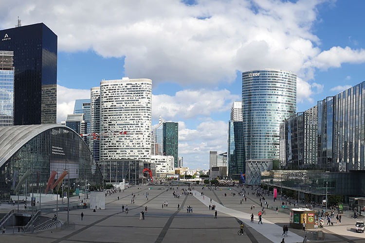 La Défense, Paris, is transitioning from a mid-century urban renewal model to a 21st century transit-oriented neighborhood. © Bretwa (cc by-sa)
Due to the postwar economic boom, a growing need emerged to accommodate urban development without damaging the historic fabric of Paris. Located at the end of the Axe Historique, a 10-kilometer long historical axis which starts at the Louvre in Central Paris and includes the Champs-Élysées, the Arc de Triomphe and the crossing of the Seine River, La Défense had been targeted as a redevelopment area by local authorities in the mid-1950s. A master plan, created in 1958, specified that La Défense was to be completed within 30 years.
Centered around Centre National des Industries et des Techniques (CNIT), a large exhibition hall, La Défense evolved into an urban district set around a raised concrete plinth for pedestrians, with the road network submerged below. The total program of development was 85 hectares. By 1970 the regional urban rail network RER reached the district, and Etablissement Public d’Aménagement de La Défense (EPAD), the operating authority, approved construction of 1.55 million square meters of office space (Scicolone 2012). A second wave of towers arrived, some close to double the 100-meter height limit imposed only 10 years before. The signature Grande Arche, a 110-meter monument on the axis from Paris, opened in July 1989.
By the mid-2000s, it had become clear that monumentalism alone was insufficient to the task of making a thriving community. A campaign of improvements to the public realm and the space between buildings has pushed La Défense into a more integrated position vis-à-vis the Paris metropolis, rather than a kind of fortress that stands apart. Similar projects around the world are following suit.
Potsdamer Platz, Berlin
 The rebuilt Potsdamer Platz in Berlin, Germany draws up to 100,000 visitors a day. © Avda (cc by-sa)
Once the busiest intersection in Europe, Berlin’s Potsdamer Platz became a practical ghost town after World War II, and particularly after the construction of the Berlin Wall in 1961. After the wall’s demolition in 1989, the desolate area became the focus of intense attention and debate, on how to make it a place that would heal the gash between the divided city’s halves and re-establish the city and Germany on the world stage. The city government organized a design competition, which was awarded in 1991. The master plan was divided into four zones, three of which were sold to major German corporations, which then executed construction projects in accordance with the plan.
Daimler-Benz, Sony, and Otto Beisheim (Metro AG) developed three of the zones, with a fourth becoming Park Kolonnaden, a group of buildings on the site of the former Haus Vaterland. Being such a politically and emotionally charged place, the plan naturally drew many detractors and was the subject of intense controversy. Ultimately, the rebuilt Potsdamer Platz draws up to 100,000 visitors a day, and fears that it would become a “dead zone” after business hours proved unfounded, due partly to a proliferation of cinemas on the square. The Sony Center, Bahn-Tower and Beisheim Center are now contemporary landmarks in their own right.
Middle East/Africa
Downtown Dubai, Dubai
 Downtown Dubai forged an entirely new city center around the Burj Khalifa, the world's tallest building. © Carlvic Lim
Dubai has developed rapidly from a small trading port in 1950 to a city of 4.6 million today. Its greatest acceleration occurred after 2002, when real-estate regulations were changed to allow foreign investment. From 2002 to 2008, the city’s population doubled. Downtown Dubai, developed by Emaar Properties, is perhaps the most emblematic district when it comes to the Dubai style of urban growth (Safarik, et al. 2018). The single-developer, city-scale district contains the Dubai Mall (the world’s second-largest by land area) and the Burj Khalifa, the world’s tallest building. Amid an artificial lake, the Dubai Fountain performs “jumps” choreographed to music at regular intervals; the Dubai Opera is situated on the shores of the lake. A phalanx of hotels and high-rise residential buildings surrounds the lakeside core. This particular form of urbanism relies on a central proposition: building the world’s tallest building may not, in itself, be a profitable endeavor; surrounding the Burj with a water feature and with residential and office buildings that can claim a view of the world’s tallest building, can be quite profitable, indeed.
The Corniche, Abu Dhabi
 The Corniche, Abu Dhabi is dramatically lined with an increasingly long wall of skyscrapers. © Anshul Hari
The eight kilometers of road along the shores of the Persian Gulf in Abu Dhabi barely existed a few decades ago. Until 1972 the Corniche had been little more than a sandy spit where boats could anchor and unload cargo. When the Mina Zayed commercial port opened, there was an opportunity to turn the Corniche into a public amenity. Between 2002 and 2003, the city reclaimed land from the sea and extended the Corniche, filling it with cycle paths, fountains and park areas. It is now the city’s main civic area, and is dramatically lined with an increasingly long wall of skyscrapers, as well as the Marina Mall and many hotels.
Victoria & Alfred Waterfront, Cape Town
 Cape Town's V&A Waterfront redeveloped working docks into a retail, tourism and residential development with significant cultural attractions. © Mike Peel (cc by-sa)
The Victoria & Alfred (V&A) Waterfront is a 123-hectare mixed-use development centered around South Africa’s oldest working port (V&A Waterfront 2019). Dating from 1860, the V&A has many heritage buildings, but had begun to lose economic vitality by the latter half of the 20th century. In 1988, a development company was formed as a subsidiary of Transnet, Ltd., the national ports and railways operator, to redevelop the historic docklands around the Victoria and Alfred Basins as a mixed-use area with a focus on retail, tourism and residential development with a working harbor at its center. Educational institutions, hotels, a cruise terminal, and infrastructure improvements followed. The crowning achievement that earned the V&A Waterfront global recognition was the conversion of the South African Railways & Harbours Grain Silo complex into a hotel and the Zeitz MOCAA (Museum of Contemporary Art Africa) in 2017. The project received the CTBUH Best Tall Building Middle East & Africa Award in 2018.
1 The submissions ultimately accepted for publication were sent by: Bridget Barnes, Skidmore, Owings & Merrill LLP, Chicago; Terri Meyer Boake, University of Waterloo, Toronto; Louise Chan, Frasers Property Australia, Sydney; Peter Gardiner, Peddle Thorp Architects, Melbourne; Jayme Gately, Hoerr Schaudt Landscape Architects, Chicago; Jessica Heller, Heller Manus Architects, San Francisco; Marina Miceli, Skidmore, Owings & Merrill LLP, London; Lucy Moloney, PTW Architects, Sydney; Robert Solomon, National Fire Protection Association (NFPA), Quincy; Jonathan Schifman, Skidmore, Owings & Merrill LLP, New York
References
Badger, E. and Bui, Q. (2019). “Cities Start to Question an American Ideal: A House With a Yard on Every Lot.” The New York Times. 18 June 2019. Accessed 20 June 2019. https://www.nytimes.com/interactive/2019/06/18/upshot/cities-across-america-question-single-family-zoning.html.
Barbanel, J. (2016). “The High Line's ‘Halo Effect’ on Property.” The Wall Street Journal. 7 August 2016. Retrieved 8 August 2016. https://www.wsj.com/articles/the-high-lines-halo-effect-on-property-1470608556.
City of Chicago. (2019). “Chicago Green Roofs.” Accessed 19 June 2019. https://www.chicago.gov/city/en/depts/dcd/supp_info/chicago_green_roofs.html.
City of San Francisco. (2017). “San Francisco Better Roofs.” Accessed 19 June 2019. https://sfgov.org/sfplanningarchive/san-francisco-better-roofs.
Davey, M. (2014). “A Picture of Detroit Ruin, Street by Forlorn Street.” The New York Times. 18 February 2014. https://www.nytimes.com/2014/02/18/us/detroit-tries-to-get-a-clear-picture-of-its-blight.html.
Detroit Demolition Program (DDP). (2019). Detroit Demolition Program, City of Detroit. Accessed 21 June 2019. https://detroitmi.gov/departments/detroit-building-authority/detroit-demolition-program.
Feloni, R. (2018). “Billionaire Dan Gilbert Has Already Bet $5.6 Billion on Detroit's Future, but Money Can't Solve His Biggest Challenge.” Business Insider. 18 August 2018. Accessed 21 June 2019. https://www.businessinsider.com/quicken-loans-dan-gilbert-detroit-2018-8.
Green Roofs for Healthy Cities (GRHC). (2018). “2017 Green Roof Industry Survey Shows Washington DC In Top Spot for Most Green Roofs Installed.” Living Architecture Monitor. 25 July 2018. Accessed 19 June 2019 . https://livingarchitecturemonitor.com/news/2018/7/25/2017-green-roof-industry-survey-shows-washington-dc-in-top-spot-for-most-green-roofs-installed.
Ibold, S. & Nedopil, C. (2018). “The Evolution of Free-Floating Bike-Sharing in China.” Sustainable Transport. 3 August 2018. Accessed 19 June 2019. http://www.sustainabletransport.org/archives/6278.
Larsen, R. (2017). “Detroit: The Most Exciting City in America?” The New York Times. 20 November 2017. Accessed 21 June 2019. https://www.nytimes.com/2017/11/20/travel/detroit-michigan-downtown.html.
MarketsandMarkets. (2019). “Roofing Systems Market by Material (Asphalt, Metal, Plastic, Clay, Concrete), Product (Shingles & Plates, Tiles), Construction Type (New Construction & Reform Construction), End-Use Sector (Residential & Non-Residential) – Global Forecast to 2021.” Accessed 21 June 2019. https://www.marketsandmarkets.com/Market-Reports/roofing-system-market-88256875.html.
Nonko, E. (2016). “Condos Padding the High Line are Ridiculously Pricier than Their Neighbors.” Curbed NY. 9 August 2016. Accessed 21 June 2019. http://ny.curbed.com/2016/8/8/12401622/high-line-real-estate-development-effect.
Parakh, J., Gabel, J., and Safarik, D. (2017). The Space Between: Urban Places, Public Spaces & Tall Buildings. Chicago: CTBUH.
Safarik, D., Ursini, S., and Wood, A. “The Tall, Polycentric City: Dubai and the Future of Vertical Urbanism.” CTBUH Journal 2018 Issue IV: 20–29.
Scicolone, M. (2012). “Developing Skyscraper Districts: La Défense.” CTBUH Journal 2012 Issue I: 18–23.
Tuohy, J. P. (2019). “New York City Passes Bill Requiring Green Roofs on New Buildings.” Dwell. 23 April 2019. Accessed 21June 2019. https://www.dwell.com/article/new-york-city-requires-green-roofs-on-new-buildings-ede4deb8.
V&A Waterfront. (2019). “Victoria & Alfred Waterfront.” Accessed 21June 2019. https://www.waterfront.co.za/the-va/the-company/our-history/.
Wood, A., Bahrami, P., and Safarik, D. (2014). Green Walls in High-Rise Buildings. Chicago: CTBUH/Images Publishing Group.
Get the Latest News and Updates from CTBUH
Fields with an asterisk (*) next to them are required.
View our privacy policy